with their brilliant plumage, their flashing blue heads really stand out at dusk.
Lazuli Bunting (Passerina amoena).
with their brilliant plumage, their flashing blue heads really stand out at dusk.

Lazuli Bunting (Passerina amoena).
this spring despite large flocks visiting the ground feeding stations during winter, the melodic songs of this member of the blackbird family have been missed. Here’s one today perched at the summit of a cottonwood doing his thing.

Male Western Meadowlark (Sturnella neglecta) belting out its song.
for Father’s Day.

assist these desert-adapted plants in seed dispersal by the wind. It’s feathers versus helicopter blades.

Cliffrose (Purshia mexicana).

Single leaf ash (Fraxinus anomala).
can be found in the form of guano pellets and insect parts, dropped when insectivorous bats take a short break from their nocturnal foraging activities. If you ate half your body weight in insects every night you’d need to take a break and evacuate your bowels, too.

Bat guano is an excellent fertilizer and wars have been fought over this precious resource. Sweep these nuggets of concentrated nitrogen up and toss them in your garden.
to my daily rides is increasingly necessary as it’s heading toward 100° F by the weekend.
This morning: Panorama of the Round Mountain Annex to Castle Valley National Park. (Click on image to expandify.)

The singletrack at 7:45 am MDT. Cool. Quiet. Critters. Sublime.
and summertime storm clouds blossom over the high La Sal Mountains. Less than two weeks until the summer solstice.


UPDATE: Peak flow on the Colorado River has likely just occurred, capping an unremarkable spring runoff. Here’s the one year hydrograph for the Colorado River at the Cisco gage showing that this year’s peak flow (blue line) is one-third of last year’s value (brown line) and less than half the median value (dotted line).
for laying their eggs and feeding their caterpillars as it is the only food source they can consume. Here’s one in the riparian zone of Castle Creek.

Showy milkweed (Asclepias speciosa).
of legally diverted water from Castle Creek, now being performed digitally and remotely since the Utah Department of Natural Resources has just installed a real-time monitoring point using a solar powered sonic water level sensor and radio transmitter. Previously, someone would have to visit this site and visually read the staff gage in the Parshall flume through which the water is flowing in order to calculate the flow. This new system is undoubtedly calibrated to the old staff gage, and likely radios the data in real-time, or perhaps daily.

Newly installed electronic gaging station next to Castle Creek above the town of Castle Valley. Note the metal Parshall flume box through which the water is flowing, away from the viewer in this image.

The sonic water level sensor at the upstream end of the Parshall flume. Note staff gage on side of flume.
The diverted water is claimed under three water rights granted in 1885, 1891 and 1933 for 2.0, 1.033 and 1.9172 cfs (cubic feet per second) respectively according to Utah DNR records.

UPDATE: An additional remote water gauging station has been installed on the 14-inch diameter iron pipe that transfers water from the point of diversion to the fields for irrigation lower in the valley. This is about 1.1 miles below the point of diversion seen above.
on a conspicuous perch, this hefty flycatcher does the work during the day that our bat friends do at night.

Western Kingbird (Tyrannus verticalis).
by a number of plants in sufficient amounts to be toxic, and the lemon-yellow spike-shaped blossoms of this desert beauty belie the dangerous concentration that it may contain.

Prince’s plume (Stanleya pinnata).
for pesky and persistent varmints. Meet Number 10, going for a ride. Number 11 has already been spotted, hopping around and enjoying freedom for a short while longer.

Rock squirrel (Otospermophilus variegatus).
was enjoyed today at the Ken’s Lake Proving Ground on a quiet and calm morning with two good friends.

Doorknob takes to the sky.

Arreaux lifting off with the GPS radio tracker in the payload bay.

The flight of the Arreaux at Ken’s Lake Proving Ground south of Moab, rendered on Google Earth using flight telemetry. Cool tech.
by Castleton Tower, caught on my early morning ride in the coolest part of the increasingly warm days.

of 45.9 degrees from the Sun today, making it the best time to view the planet since it will be at its highest point above the horizon in the morning sky. Here’s the so-called “morning star” rising above Adobe Mesa around 4:30 am MDT.

the Bull Pup model rocket heads skyward at the Ken’s Lake Proving Ground this morning on an Aerotech F20-7W engine. It’s a very menacing scale replica of a short-range air-to-ground missile used by the US Navy during the 1960s and 1970s, but without the ordinance onboard, of course.


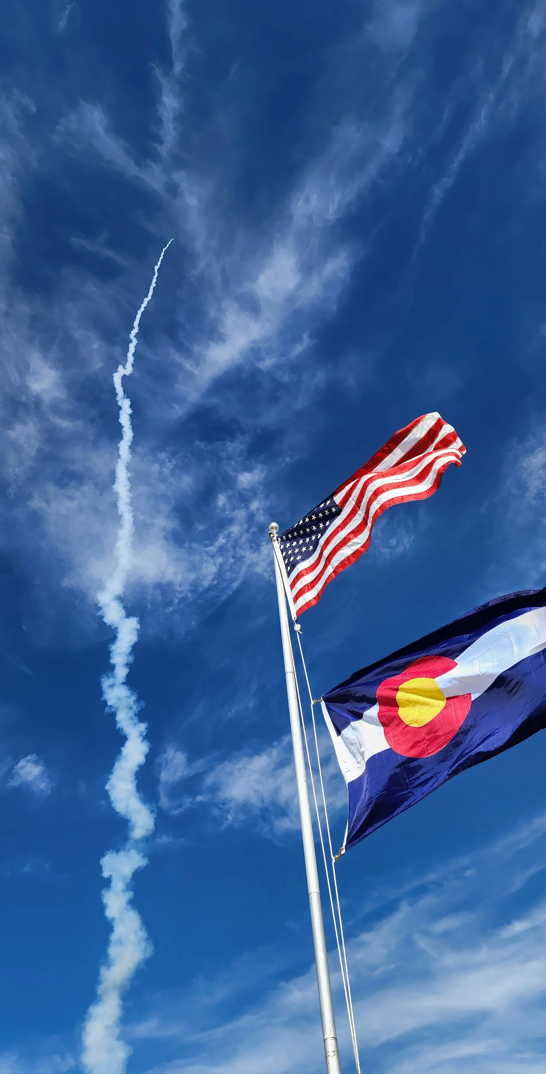
of low-, mid- and high-powered rockets occurred over four days at the National Sports Launch West event, bringing together more than 250 rocketeers from across the country for the Memorial Day weekend near Alamosa, Colorado. Here’s one of the first high-power rockets heading to 44,000 feet (13,400 meters) to kick off the event!

The high altitude launch site lies at 7,600 feet above sea level in the San Luis Valley with 80 launch pads/rods/rails/towers on the firing range. There’s nary a tree for miles and miles in any direction.

All launch pads and rockets on the range are fired by the Launch Control Officer and their staff of assistants, pad managers and spotters.

All rockets to be flown are first inspected by Range Safety Officers for flight worthiness prior to launch, no matter the size, both large and small.

GPS radio tracking frequencies must be managed so as to avoid conflicts during flights.

Basic kits were generously donated by Estes and the rocket engines by Chris’ Rocket Supplies for the kids.

Many vendors were represented at the event and a lot of business was conducted on the site.
the Gunnison River has deeply incised the Black Canyon, exposing the ~1.7 billion year-old Precambrian metamorphic rock that comprises the enormous Painted Wall, caught at sunrise and the moment of first light.


Wide pre-dawn view of the 2,250 foot (686 meter) high Painted Wall, showing pegmatite dikes intruding the foliated gneiss and schist creating a natural abstract mural nearly a half-mile high.

Bighorn sheep (Ovis canadensis) enjoying sunset near Cedar Point the evening before.
keeps this flycatcher busy and it is now being frequently observed around the house.

Western Kingbird (Tyrannus verticalis).
for the National Sports Launch West to be held near Alamosa, Colorado during the upcoming Memorial Day weekend, a four day-long event. Launch waivers to 52,000 feet!!

The Arreaux (left) and Arcas (far right) are the highest fliers, and they will carry the GPS radio tracker in their payload bays.