but still enjoying munching on succulent cheatgrass.
Desert cottontail (Sylvilagus audubonii).
but still enjoying munching on succulent cheatgrass.

Desert cottontail (Sylvilagus audubonii).
is being brightly expressed in Castle Valley. There’s a real chill in the air, too.

occurred above the bridge on Castleton Road during this summer’s flooding, clearly evident from examining these images taken three years apart. Compare and contrast.

THEN: Castle Creek on 17 November 2021.

NOW: Castle Creek on 31 October 2024.
across the eastern horizon during this morning’s sunrise behind Adobe Mesa, a welcome warmth following the first hard freeze of the season last night.

in the first-order drainage basins beneath Adobe Mesa, with dramatic views to the northwest towards Castleton Tower, The Rectory and Parriott Mesa. A lovely but chilly autumn day.


at Castleton Tower commenced around noon and lasted through the late afternoon. I suspect some poor climber is in distress.


UPDATE: Full story in this week’s Castle Valley Comments.
throughout Castle Valley is clearly seen in the recently updated satellite imagery available in Google Earth and Google Maps. Light-colored sedimentary deposits paint the areas affected by overland sheet-flooding and where floodwaters escaped ditches and natural channels. Compare and contrast.

Imagery date: 7 August 2024.

Imagery date: 14 October 2022.
Hint: Learn to use the time slider tool in Google Earth to time travel into the past and examine earlier satellite imagery.
from the lawn, this phallic fungus emerges on schedule in October. About a half dozen of these pungent and indecent structures have developed so far, likely triggered by the recent rains. Impressive.

Common stinkhorn (Phallus impudicus).

Odorous chemicals in the slimy cap attract insects which will collect spores and spread them to other locations.

UPDATE: The following day, still standing erect but the cap has been consumed by insects, still attracted to the pungent odors.

and signals a good start to the water year. I recorded a half-inch (12 mm) of liquid sunshine in my rain gauge yesterday.

The snowy summit of Mt. Waas is 12,306 feet (3,751 meters) in elevation and about 12 miles (19 kilometers) distant. Round Mountain in foreground.
shortly after sunset this evening, low to the west, hovering midway between Venus and Arcturus. Its size and brightness exceeded my expectations and the comet was easily observed with the unaided eye around 8 pm MDT as I snapped a series of images using different lenses.

Despite the nearly full Moon, the comet was initially spotted with binoculars, and then it became an easy naked eye object.

An automobile zooms along Highway 128 on the right, the occupants of which have no idea of the astronomical spectacle they are missing. That’s the planet Venus shining brightly in the lower left of the frame.

Telephoto shot of comet nucleus and tail that stretches more than five degrees across the night sky.
this evening where there’s an unobstructed view of the western horizon across the flat and desolate landscape of Sagers Wash. I was out of the canyons, chasing a comet yet again, and all I came home with was this lousy sunset. No complaints, it was an absolutely lovely evening.


in the 21st century with a historic launch and capture of the largest object ever put into space early this morning. It’s unfortunate that this incredible accomplishment isn’t receiving more news coverage.
I’m not so sure that Elon Musk isn’t an alien.
Images below are screenshots from the live stream provided by SpaceX.

One minute before launch the Super Heavy Booster and Starship are fully fueled with liquid oxygen and liquid methane.
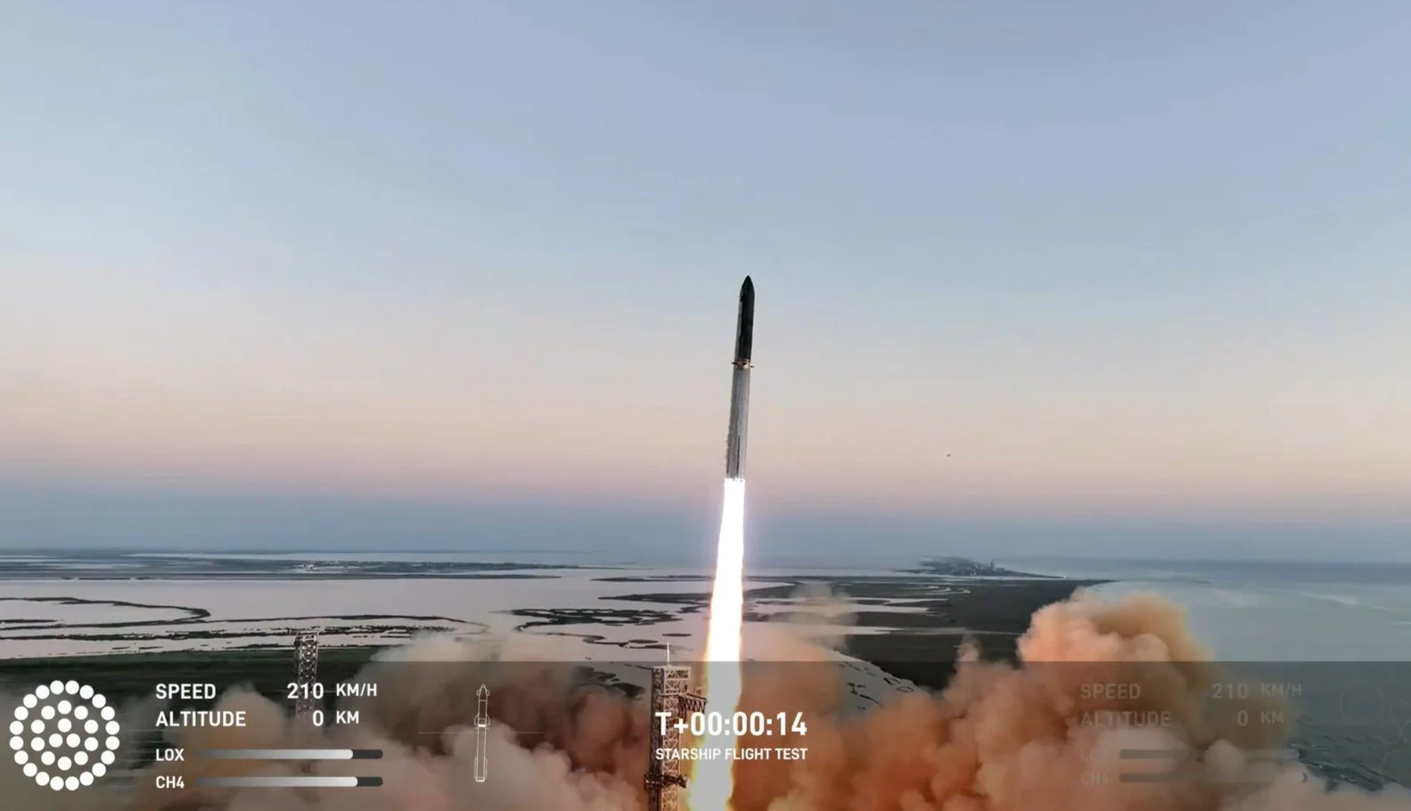
Liftoff as 33 Raptor engines on the Super Heavy Booster generate twice the thrust of the Saturn V, capable of placing 150 tons into Earth orbit.

Super Heavy Booster hovering at the launch tower after return from flight. Entirely unprecedented. Wow!

The captured Super Heavy Booster hanging from the “chopsticks” post flight as the vehicle undergoes depressurization.

Glowing plasma during controlled re-entry of Starship during peak heating prior to a successful soft landing on target in the Indian Ocean. Hi-res images provided by Starlink.
Video: Drone’s-eye-view of the liftoff.
Video: The tower catching the returning Booster!
Video: The landing burn and soft touchdown of Starship.
It’s pretty clear that NASA needs SpaceX more than SpaceX needs NASA. Per aspera ad astra.
paint a slowly evolving and colorful kaleidoscopic display across the northern horizon shortly after sunset, seen below centered on Parriott Mesa. Magnificent.


in Castle Valley, Utah was an outdoor wiener roast, generously hosted by the Hatch family this evening, with more than 60 people attending. Could there be a nicer group of folks or a better location?

for the third day is affecting the eastern Utah region due to the Yellow Lake fire in the western Uintah Mountains. It’s going to take a change in wind direction to clear out the smoke and haze.
Link to Fire and Smoke Map 4.0 for latest air quality conditions.

Smoky conditions in Castle Valley obscure the higher La Sal Mountains and Round Mountain shortly after sunrise.

Fire and Smoke Map for Monday morning, 7 October 2024, showing location of Yellow Lake fire and associated smoke plume. Color-coded circles are air quality measurement stations.
from high in a cottonwood tree.

Common Raven (Corvus corax).
again in Castle Valley, Utah with the Trek full suspension e-mountain bike turning 3,000 miles on today’s ride. Since September 2020 the cumulative mileage on all my eMTBs comes to 14,357 miles (23,110 kilometers), or 57.6% of the Earth’s circumference at the equator. I’m feeling a bit like Forrest Gump during his running phase.

paints this golden panorama of an amazingly scenic terrain. I was out in the predawn to chase an early morning comet, but having met with no success, I returned with this expansive image. It’s a helluva back yard. You’d think the movie industry would like to film around here.
Click on the annotated image to expandify.
in remote northern Utah displays all the rocket engines and missiles they manufacture at full scale, now under corporate ownership by Northrop-Grumman. I have an enormous case of rocket envy.

The rocket garden is free and open daily to the public and includes interpretive signs and related displays. Well worth a visit if you’re heading to the Golden Spike National Historical Park which is nearby.

The submarine-launched ballistic Trident (center) with the three-stage land-based Minuteman ICBM (left of center). The enormous solid rocket booster for the Space Shuttle lays in the background.

The business end of the Space Shuttle’s solid rocket booster. When ignited, a pair of these provided 85% of the thrust at liftoff for the first two minutes of ascent. Unfortunately there are no demonstrations.
Location on Google Maps: 41.65892098884914, -112.44084106450782
after the summer’s absence via the San Rafael Swell. There’s no place like home.

Milky Way galaxy erupting a fountain of stars and nebulae, geyser-like from the rim of the Little Grand Canyon of the San Rafael River.
Sunrise from the Wedge Overlook, northern San Rafael Swell. Click on image to enlarginate.
The magnificent Buckhorn Wash pictograph panel. Click on image to embiggen.

The remote San Rafael River “Swinging Bridge” built 1935-1937 by the Civilian Conservation Corps, listed on the National Register of Historic Places.