is a lovely tyrant flycatcher, whose family has nested at my neighbor’s home ever since it was built in the early 2000s.
Say's Phoebe (Sayornis saya).
is a lovely tyrant flycatcher, whose family has nested at my neighbor’s home ever since it was built in the early 2000s.

Say's Phoebe (Sayornis saya).

as yet another snow squall rolls across the La Sal Mountains this chilly evening.


Whipple's fishhook cactus (Sclerocactus whipplei).

Claret cup cactus (Echinocereus triglochidiatus).
across my daily mountain biking route is not something that one encounters every day. Ranchers are moving cattle from Professor Valley and along the Sylvester Trail as I hang back to let them pass.
Click on image to embiggenate.
in the British Isles and Norwegian fjords, a small ship trip with Apex Expeditions, departing late this month. Here’s a map showing our intended travels and a link to the detailed itinerary.
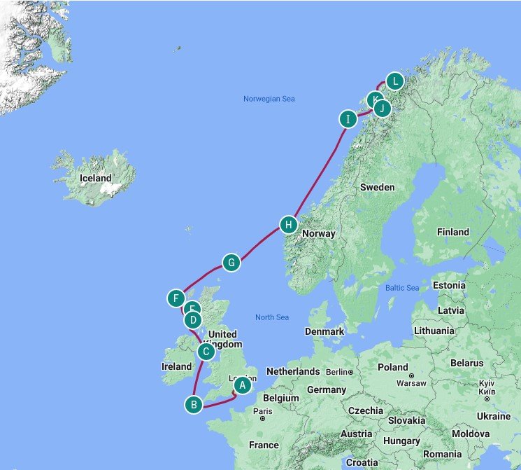
I’ve worked this region before with Apex, and there is a “British Isles” portfolio of images in the Gallery. Navigate to the main menu and enjoy.
is frequently seen and heard rummaging through the saltbush and rabbitbrush for an insect meal.

Spotted Towhee (Pipilo maculatus).
the high desert plants begin the blossoming parade in Castle Valley.

Yellow cryptanth (Cryptantha flava).

Indian paintbrush (Castilleja linariifolia).
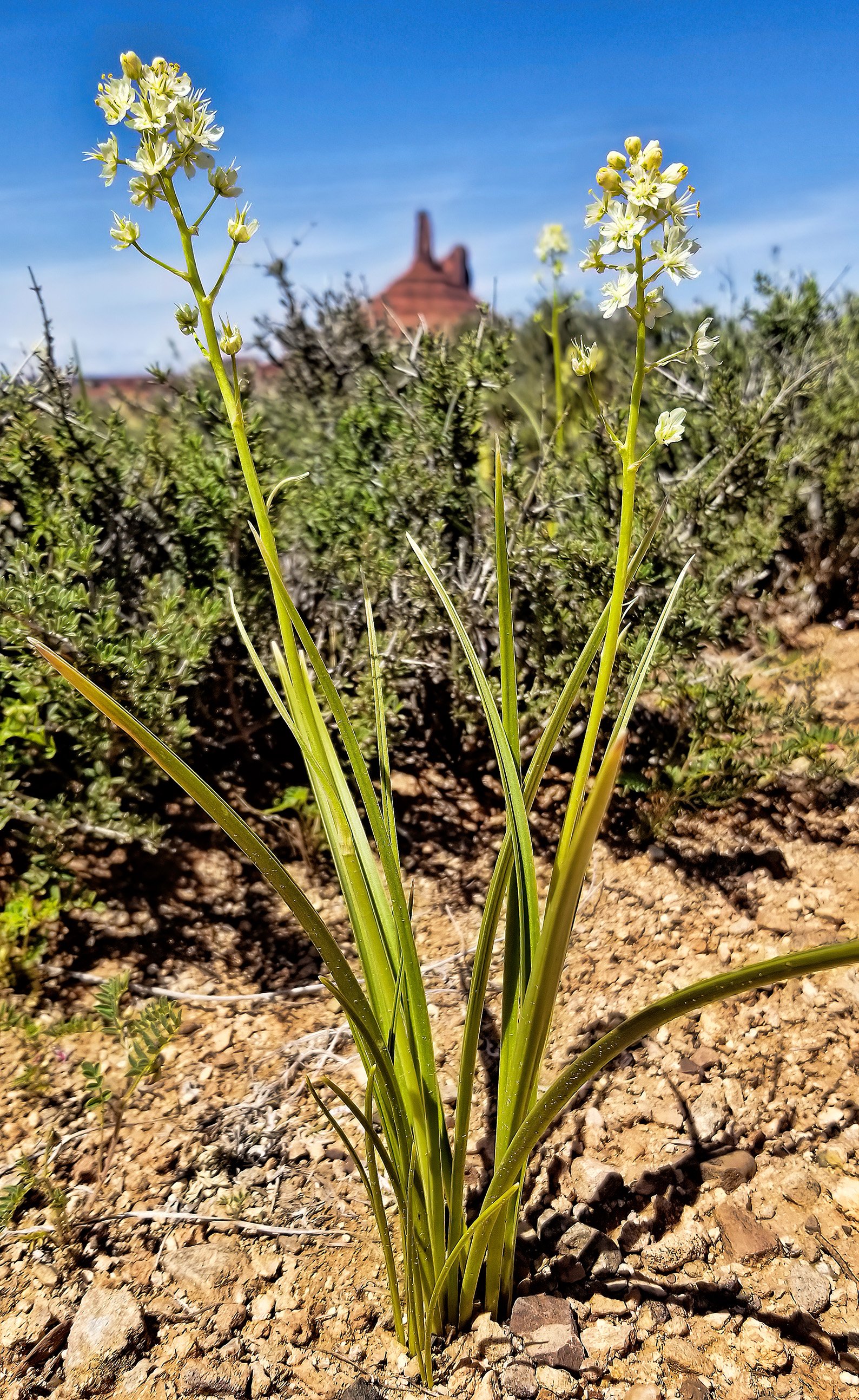
Panicled death camas (Toxicoscordion paniculatum).
of Castle Valley from a high point near Castleton, Utah. This panoramic view was captured yesterday during a 22 mile ride (2,560 foot ascent) with my neighbor on our awesomely fun eMTBs.
Another lousy day in Utah! (Click on the annotated panorama to embiggen.)
named after an early western naturalist.

Newberry’s twinpod (Physaria newberryi).
lies a most peculiar petroglyph, pecked into a varnished sandstone wall at the base of the Wingate escarpment.

Snow squall over Grand View Mountain, the northernmost peak in the La Sal Mountain range.


Note the odd conjoined twin anthropomorphic figures at the center of this image.
after a terrific three day-long road trip from Astoria, Oregon. Feels good to be ensconced in red cross-bedded sandstones once again.


On a walkabout with friends visiting from Canada.

Utah penstemon (Penstemon utahensis).
is sustained by groundwater discharging from a series of large springs at the base of the east side of the Ruby Mountain range in northern Nevada.

Adult male Cinnamon Teal (Spatula cyanoptera).

Adult male Lesser Scaup (Aythya affinis).

Adult male Eared Grebe (Podiceps nigricollis).
in Nevada and Utah includes the most remote and loneliest part of the western US, and all the rivers are internally drained, that is, have no outlet to the oceans.

Endless mountain ranges, endless empty valleys.

There’s copper in them thar hills: Variegated mine dump at Ruth, Nevada.

in central Oregon greets the dawn with a light morning mist hanging in the low wetland pockets.


Sandhill Cranes (Antigone canadensis). Side note: These birds funded my M.S. thesis on the fluvial sedimentology of the Niobrara River in Nebraska. Thanks!
the morning I completed my fire fighting training for certification to crew vessels at sea as an expedition staff member. The specialized facility is located near this scenic port town.

The Astoria–Megler Bridge spanning the Columbia River.

Pre-drill briefing before fighting a simulated engine room fire.

The flames are real, and the smoke is a dense but non-toxic mineral oil vapor, harmless if inhaled.
The fire fighting training drills consisted of working with full gear and respirators, navigating out of a smoke-filled three-story building, dowsing liquid fires with dry chemical and CO2 extinguishers, as well as working with fire hoses in teams attacking three simulated fires. It was interesting and fun but very exhausting.
is a new gallery that I just created that includes a collection of images taken in early April 2022 when I was guiding for Apex Expeditions. Navigate to the main menu, select Gallery and enjoy.

The stair-stepped golden falls of Gullfoss with a vibrant rainbow in the rising spray.
of Iceland was achieved by our group with Apex Expeditions the last two weeks, our travel trajectory across the country plotted on the map below.
GPS track of our counter-clockwise journey around Iceland from my Garmin Fenix 6X Pro watch. It records waypoints every few hours when in “expedition mode.” (Click on image to embiggenate.)
as observed from 38,000 feet by this window-seated geologist during my return flight from Iceland.

East coast of Greenland locked in sea ice.

Immense valley glaciers in Greenland’s interior. Note the two crevassed tidewater glaciers at bottom center.

Deeply carved rock walls on Nunavut.

April ice breaking up on Hudson Bay.
stands in isolation at Búðir on the storm-beaten southern coast of the Snæfellsnes peninsula, painted and sealed with pitch to withstand the harsh elements.


Snæfellsjökull is the dominant stratovolcano at the western tip of the Snæfellsnes peninsula, rising to 1,446 meters (4,744 feet), and the fabled entrance to the center of the Earth according to Jules Verne.

View of glacier-capped Snæfellsjökull from the air on my return flight from Iceland.
are small but long-lived and hardy working animals.


