High temperature records...

are being broken throughout the Pacific Northwest today, even here in the Spokane area, where temperatures have risen to 110 deg F at my cabin in the pines! The heat seems to be following me, so it’s time to pump up the stand-up paddle board and hit the local lakes.

Click on the graph showing the annual high temperature at the Spokane International Airport since 1890 to enlarge. The two warmest points on the time series are both 208 deg F, occurring in 1928 and 1961.

And it’s not over yet. Here’s the forecast:

pnw heat wave graphic.JPG

UPDATE: The official temperature recorded at the airport was 109 deg F at 4:00 pm PDT on 29 June 2021 making it the highest temperature recorded during the period of record, and the highest temperature in 60 years. This is weather, not climate.

This wise owl...

is perched on the shady side of a ponderosa pine tree on this 100+ deg F afternoon, about 20 feet directly above the water-filled birdbath!

Well camouflaged Great Horned Owl (Bubo virginianus).

Well camouflaged Great Horned Owl (Bubo virginianus).

UPDATE:  Trailcam image caught at 9:43 pm PDT the following evening!

UPDATE: Trailcam image caught at 9:43 pm PDT the following evening!

British Isles image collection...

has been added to the Gallery and features photos that I captured in 2019 with Apex Expeditions during our circumnavigation of the archipelago, including the Shetlands, Saint Kilda, and Fair and May Isles. Use the main menu to navigate to the Gallery and enjoy!

Atlantic Puffin (Fratercula arctica).  I’m told by my Icelandic friends that they are not only cute, but delicious too!

Atlantic Puffin (Fratercula arctica). I’m told by my Icelandic friends that they are not only cute, but delicious too!

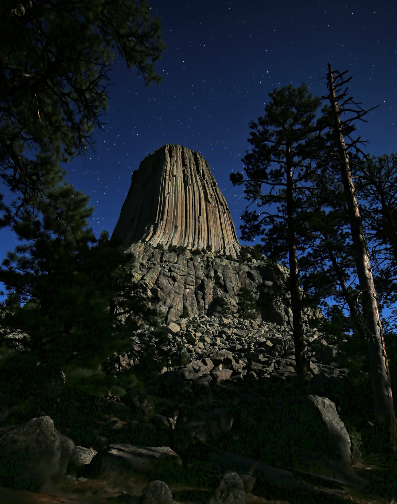
Moonglow at Devils Tower...

dramatically illuminates the landscape but, unfortunately, the nearly-full orb brightens the night sky so much that the Milky Way vanishes from view.

North side of Devils Tower shot at 2 am MDT from the Joyner Ridge trailhead.  That’s Jupiter to the left of the Tower and Saturn above and slightly to the right.  Ordinarily the Milky Way would appear in this frame to the right of the Tower but the Moon brightens the sky too much for it to be visible.

North side of Devils Tower shot at 2 am MDT from the Joyner Ridge trailhead. That’s Jupiter to the left of the Tower and Saturn above and slightly to the right. Ordinarily the Milky Way would appear in this frame to the right of the Tower but the Moon brightens the sky too much for it to be visible.

View of south face from Tower Trail, shot at 11 pm MDT and entirely illuminated by moonlight.

View of south face from Tower Trail, shot at 11 pm MDT and entirely illuminated by moonlight.

Star trails shot between 10:30-11:00 pm MDT showing the south face of Devils Tower.  The white streaks across the lower part of the image were made by late-night hikers and their flashlights.  They never knew I was there!  Heh.

Star trails shot between 10:30-11:00 pm MDT showing the south face of Devils Tower. The white streaks across the lower part of the image were made by late-night hikers and their flashlights. They never knew I was there! Heh.

Devils Tower National Monument...

was the focus of yesterday afternoon and evening. It’s a small but magnificent (and the first) National Monument.

devils-tower-north-side-wide.jpg
devils-tower-south-face-portrait.jpg
I’ve climbed the ~870 foot (265 meters) high columnar edifice twice, using the classic Durrance Route, just to the right (inside) the shadow line in the center of the image.  This fantastic climb was pioneered in 1938 by Jack Durrance and Harrison Butterworth, the second ascent of the Tower.

I’ve climbed the ~870 foot (265 meters) high columnar edifice twice, using the classic Durrance Route, just to the right (inside) the shadow line in the center of the image. This fantastic climb was pioneered in 1938 by Jack Durrance and Harrison Butterworth, the second ascent of the Tower.

Dinosaur Park...

high on a ridge in downtown Rapid City, South Dakota. The display consists of about a dozen life-size sculptures of the more common/popular dinosaurs. Sorry, no raptors here. This kid still loved the visit.

dino-park-duckbill.jpg
dino-park-stegosaurus.jpg

Kremmling Cretaceous Ammonite Site...

is a protected natural area administered by the Bureau of Land Management north of Kremmling, Colorado. Absolutely worth a visit and absolutely NO collecting!

The site is strewn with many dozens of these incredibly preserved specimens.

The site is strewn with many dozens of these incredibly preserved specimens.

Typical ammonite mold, approximately 75 cm in diameter.  Note the light-colored nacre (mother of pearl) material immediately to the right of my foot.

Typical ammonite mold, approximately 75 cm in diameter. Note the light-colored nacre (mother of pearl) material immediately to the right of my foot.

Detail present on several specimens showing interior chambers and suture pattern.  Based on these details, the species has been identified as Placentceras meeki.

Detail present on several specimens showing interior chambers and suture pattern. Based on these details, the species has been identified as Placentceras meeki.

Ugh it's hot...

but at least it’s a dry heat! It is, however, enough to send me packing, northward, in a couple of days.

The indicated relative humidity seen here is significantly elevated in the house due to the wonderful moisturizing effects of the swamp cooler.

The indicated relative humidity seen here is significantly elevated in the house due to the wonderful moisturizing effects of the swamp cooler.

Black widow safari...

last night yields this lovely lady wrapping up a small morsel. There is no mistaking these fascinating creatures with the signature red hourglass on the abdomen. Sometimes I feed them by tossing a cricket into their ratty, but strong, webs!

Female western black widow (Latrodectus hesperus,).

Female western black widow (Latrodectus hesperus,).

Fire never sleeps...

as the Pack Creek fire continues to burn through the night, clearly seen in this image shot at 2:30 am MDT.

Jupiter and Saturn hover above the incandescent glow of the Pack Creek fire as the Milky Way rises over Porcupine Rim in Castle Valley, Utah.

Jupiter and Saturn hover above the incandescent glow of the Pack Creek fire as the Milky Way rises over Porcupine Rim in Castle Valley, Utah.

Pack Creek fire...

flares again on this extremely hot and dry afternoon. The fire complex has grown to nearly 6,000 acres in size over the last four days and is located about 11 miles south of Castle Valley.

pack-creek-fire-plume-13-june-2021.jpg
pack-creek-fire-plume-rising-13-june-2021.jpg
Aerial image taken by Great Basin Team 4 (https://data.timestelegram.com/fires/incident/photograph/7529/1/112983/).

Aerial image taken by Great Basin Team 4 ((Link)).

Map from Utah Department of Natural Resources.

Map from Utah Department of Natural Resources.

Fire season commences...

with explosive vigor in the Pack Creek drainage in the foothills of the La Sal Mountains, just south of Moab, Utah. This fire broke out yesterday and filled Castle Valley with smoke beneath mostly cloudy skies, with most of it clearing out overnight. Then today, shortly after noon, the strong winds fanned the fire into full intensity once again. Yikes.

View from Castle Valley of smoke plume from the Pack Creek fire rising above Porcupine Rim. Strong westerly winds are driving the plume across the La Sal Mountain front. (Click on panorama to enlarge.)

pack-creek-fire-plume-across-la-sal-mtns-june-2021.jpg
pack-creek-fire-plume-june-2021.jpg
Around 3 pm MDT the smoke plume grew considerably larger in size.

Around 3 pm MDT the smoke plume grew considerably larger in size.

Image captured around 5 pm MDT showing development of pyrocumulus clouds above the smoke plume.

Image captured around 5 pm MDT showing development of pyrocumulus clouds above the smoke plume.

Here are live updates. Spoiler: The fire was human-caused by an unattended campfire, according to the U.S. Forest Service and Utah Department of Natural Resources.

UPDATE: This image was captured around 7 pm MDT. (Click on image to enlarge.)

Star trails over Castle Valley...

and a bonus meteor (!) as twilight descends on the landscape. This shooting location is in Professor Valley, immediately to the east of Castle Valley, just on the other side of Castleton Tower. This image was shot as I scouted a location for capturing the Milky Way later in the evening, rather, early the following morning.

Cumulative twenty minute-long exposure consisting of 40 individual images, each 30 seconds long, stacked and blended with StarStax software.

Cumulative twenty minute-long exposure consisting of 40 individual images, each 30 seconds long, stacked and blended with StarStax software.

Core of the Milky Way framed between Adobe Mesa (left) and Castleton Tower, the Rectory, Priest and Nuns (right).

Core of the Milky Way framed between Adobe Mesa (left) and Castleton Tower, the Rectory, Priest and Nuns (right).

Parriott Mesa silhouetted...

by the majestic Milky Way galaxy. This was a spur-of-the-moment shot as I was driving home from Professor Valley around 3:30 am. I’m glad I stopped!

Image beta:  Tripod-mounted Canon R6 with Canon EF 16-35 mm lens at 16 mm focal length in vertical orientation, ISO 6400, 20 seconds at f/4.

Image beta: Tripod-mounted Canon R6 with Canon EF 16-35 mm lens at 16 mm focal length in vertical orientation, ISO 6400, 20 seconds at f/4.