in the cedar tree outside my front window, as a Sharp-Shinned Hawk patrols the feeding station.
Dark-eyed Junco keeping a watchful eye.
This sparrow crunches his sunflower seed in the safety of the hide.
This sparrow is chomping on an ice crystal.
in the cedar tree outside my front window, as a Sharp-Shinned Hawk patrols the feeding station.

Dark-eyed Junco keeping a watchful eye.

This sparrow crunches his sunflower seed in the safety of the hide.

This sparrow is chomping on an ice crystal.
setting behind Porcupine Rim early this morning, the last full moon of the year. I get up early so you don’t have to, even in 5 degree F temperatures!

after the slow-moving snowstorm that dropped about seven inches on Castle Valley during the last two days.
The view behind, and ahead (seen below), on my afternoon ride. (Click image to enlarge.)

Fat tires rule in these conditions! Where’s everyone else?
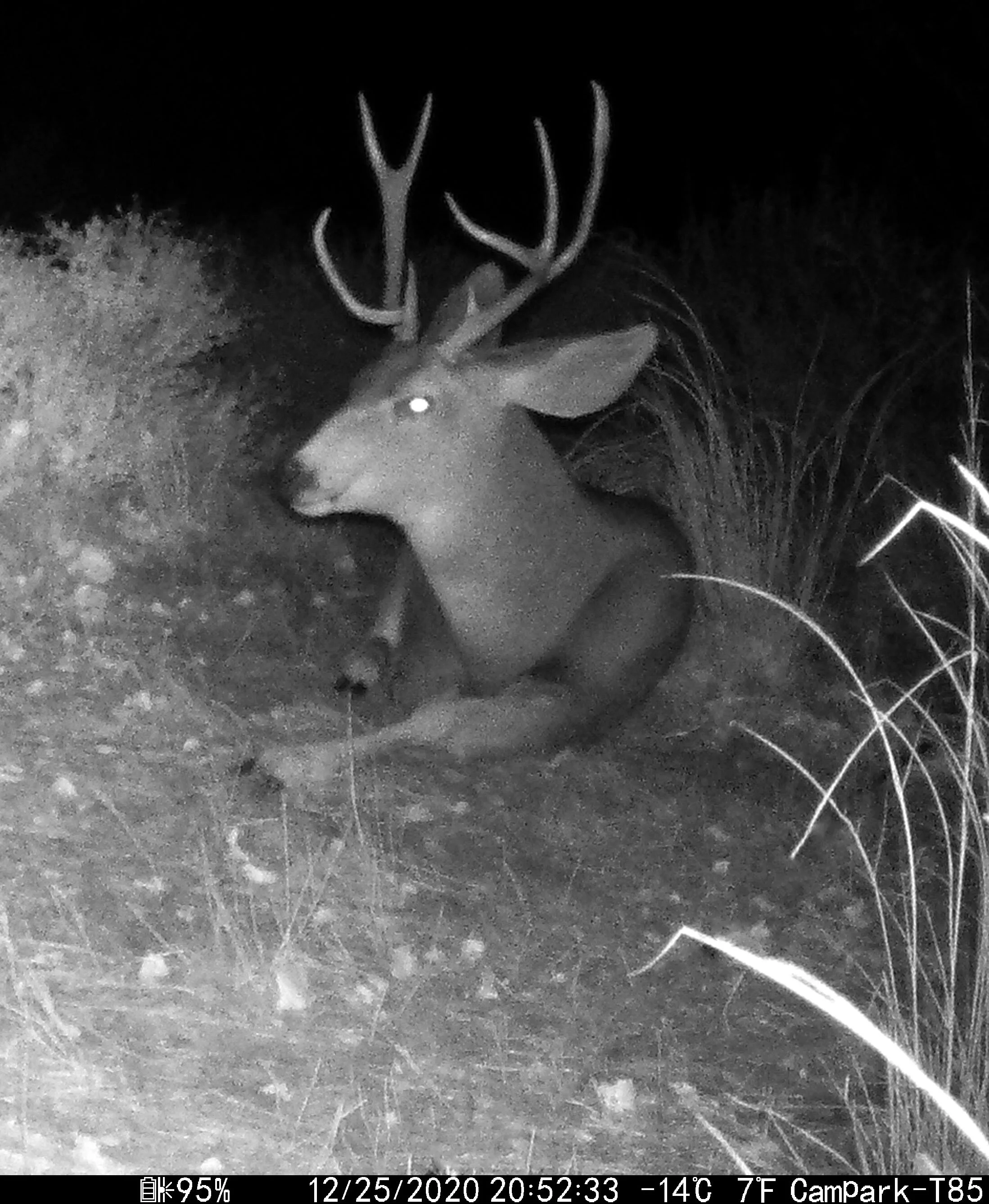
after assisting Santa’s reindeer on their delivery route in Castle Valley, Utah.


There’s a herd of about 18 of these friendly creatures that regular chill out on my property, less than 10 meters from my door. There’s no hunting allowed in the community, and I don’t have a dog, so this is a quiet place to hang out. They even watch me when I’m out doing my astrophotography thing!
parallels the south bank of the Colorado River downstream from Moab, Utah, then winds through a narrow, meandering Wingate-walled canyon before ultimately cresting out at Hurrah Pass.

The “Birthing Rock” in the Kane Creek area displays a variety of petroglyphs attributed to the Ute Indians who lived in the area from 1300 AD up to 1880. This image spans an area of about two meters square to give a sense of scale.

End of the ride today at Hurrah Pass, 20 miles out-and-back, with 1,800 feet elevation gain.
Panoramic view from summit of Hurrah Pass, near the crest of the Kane Creek anticline. Look closely and one can spy the solar evaporation pond terraces across the Colorado River. (Click image to enlarge.)
View across Kane Springs Creek from below Hurrah Pass, where the Cutler Formation is exposed in the valley bottom. (Click image to enlarge.)

Kane Creek Road to Hurrah Pass (red) completes a triptych of rides in and around the Intrepid Potash solution mining operation. The green and blue tracks show previous rides in the area on the Potash Road and at Dead Horse Point State Park, respectively.
between Moab and Castle Valley sometime today. This part of the Wingate escarpment along the Colorado River had been previously shedding rocks a few months before (on 18 August), but this large rockfall placed enormous sandstone blocks in the river. New obstacles for next year’s river runners.


In speaking with some residents in Castle Valley, the consensus is that this occurred sometime mid-day today, and is not correlated with the small local tremor of the 20th.
the Great Conjunction I was up early and caught a transit of the ISS heading northeastward, above Castleton Tower and the Rectory, where it was eventually lost in the light pollution from Grand Junction, Colorado.

Approximately two minute-long exposure with a tripod-mounted Canon 6D and Rokinon 14 mm lens, f/4, ISO 400.
as the orbital dance of the planets in the solar system bring Jupiter and Saturn within 0.1 degrees of one another, at least as viewed by Earthlings on this winter solstice.

The Galilean moons of Callisto, Io and Europa make an appearance during the Great Conjunction of 2020.
if it is at all possible during this annus horribilis. At least the days will start getting longer.

Fresh brown bear scat, Kamchatka, 2010.
I bundled up and shot these images as Jupiter and Saturn approach each other for their closest encounter in more than 800 years.
Full frame shot with, serendipitously, a jet contrail catching the setting sun above Porcupine Rim.
apparently shook the local region at 2:11 am MST, but the minor earthquake was entirely unnoticed by me, fast asleep in Castle Valley, Utah. But there are in fact 16 “felt” reports at the USGS website. So here’s the technical information about the less-than-eventful event: M 4.3 - 28 km E of La Sal, Utah

Map from the U. S. Geological Survey showing epicenter. Red symbol indicates Castle Valley, Utah.
near Moab, Utah has always struck me as an appropriate set for the old science fiction television series The X-Files given its remote location and peculiar appearance. The salt mining operation spans about five square miles adjacent to the Colorado River where the water is utilized to solution mine the salts below ground contained in the Paradox Formation (Permian).

Image of solar evaporation ponds at Potash, Utah, taken by an astronaut aboard the International Space Station in 2017. NOTE: North is toward bottom of image.

My 16 mile ride today, out and back, in red, from the Intrepid Potash processing plant to the solar evaporation pond complex. The blue track is from a prior ride last week in Dead Horse Point State Park.

Jug Handle Arch in the Wingate Sandstone on Potash Road, just before arriving at the mine site downstream from Moab.
Potash solar evaporation pond 1 A. (Click image to enlarge.)
Potash solar evaporation pond 3 B. (Click image to enlarge.)
View across crest of the Kane Creek anticline with the majestic La Sal Mountains lightly draped in early winter snow. (Click image to enlarge.)
Here’s the corporate website for Intrepid Potash if you want to learn more about their operations and products, and a brief explanation at NASA’s Earth Observatory website.
by a kit fox that apparently likes the grapes I left out last night (but it left the stems).


of Jupiter and Saturn will occur in about a week, during the early evening of the winter solstice in the northern hemisphere, on 21 December 2020. The two gas giant planets will slide within 0.1 degrees of one another and seemingly appear as a single bright star. Learn more about the exceedingly rare upcoming event here. If you’re keen on trying to observe or photograph the event here’s a terrific article by Alan Dyer.
Cast your gaze towards the southwest shortly after sunset and you’ll spot the following:
has a fantastic mountain bike singletrack around the edge of the plateau with commanding views of the incised canyons of the Colorado River.
The classic viewpoint in the park, standing on the Kayenta Formation atop the Wingate escarpment, gazing south across an entrenched meander on the Colorado River. (Click image to enlarge.)

My track, recorded by the GPS on my Garmin Fenix 6X Pro watch. “Laps” are two-mile marks. I parked outside the park at the point marked Lap 10 on the left and rode the loop counterclockwise.

Potash solar evaporation ponds in the foreground of the Kane Creek anticline.

Intrepid Potash processing plant on the Colorado River (left of center) on the northeastern limb of the Kane Creek anticline. The evaporation ponds are out-of-sight in this view, tucked behind the shadowed escarpment on the right.
down the axis of Castle Valley this early evening.

This is an approximately 120 second-long exposure, hence the elongated stars. The brightest smudge (top center) is the planet Mars.
on a clear and cold early evening.
I’ve added faint lines to highlight the constellation Orion, and that’s moonglow silhouetting Castleton Tower in advance of moonrise. (Click image to enlarge.)
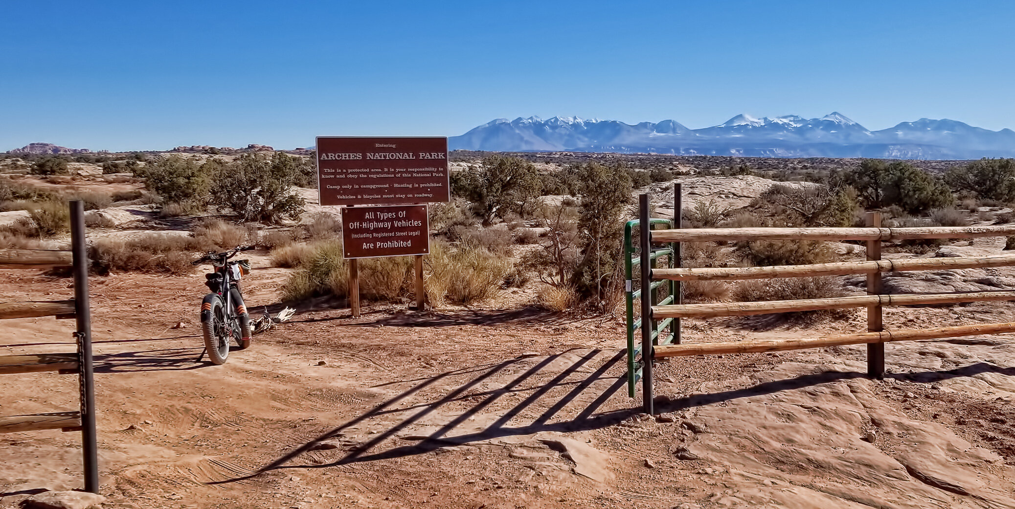
was the former entrance to Arches National Monument prior to 1958, connecting today to the modern Arches National Park road at Balanced Rock.

The back gate to Arches National Park. I had my lifetime pass with me just in case the entrance was staffed!

Some mediocre therapod tracks nicely exposed on a bedding plane in the Navajo Sandstone.

Balanced Rock along the main road in Arches National Park.
The view through the Eye of the Whale Arch in Herdina Park, a seldom-visited remote part of Arches National Park. (Click image to enlarge.)
The GPS track (red) for my 20 mile ride, involving 1,650 feet elevation gain, out and back. Fun! The modern paved ANP road is portrayed in yellow. (Click image to enlarge.)
Here’s a nice article that summarizes the history of Arches National Monument/Park: History to Go: Arches National Monument.
the Garmin inReach Mini emergency transmitter that utilizes the Iridium satellite network on my solo adventures. It’s truly small and compact and lightweight, but you also need an active subscription plan for tracking, messaging and interactive SOS.

As you can see, the device is truly tiny. There’s no excuse not to carry one if you frequently wander off the beaten track. I’ll even carry this on my various expeditions around the world, as it has global coverage, pole to pole.
over Castle Valley, Utah, the morning of 30 November 2020. Yes, it’s underwhelming, even though this image was captured at the peak of the eclipse at 2:42 am MST. Notice that the upper right quadrant is noticeably darker than the rest of the orb.

Handheld shot with a Canon EOS 5Div with 500 mm prime lens, ISO 100, f/11, 0.5 sec exposure.