on the face of Adobe Mesa at sunset during this time of year. The shadow will slowly creep further westward (to the right) over the next two months when it will nearly align with the prominent prow on the summer solstice. The Tower is nature’s sundial, a natural time-keeping gnomon.

More senseless closures...
of long existing roads in Castle Valley by the tools at the Bureau of Land Management. This one will make vehicular-assisted evacuations in case of search and rescue at Castleton Tower a bit more problematic. Real smart.

Someone is going to be injured by the much-too-thin and virtually invisible wire cable that is strung between the newly installed posts.
One of the closure signs recently installed by the BLM elsewhere in Castle Valley and shown in a previous blog post has already been ripped down. Hayduke lives!
The Ken's Lake Proving Ground...
in the southern Spanish Valley is a nice alternative launch site for higher powered rockets. Several were fired off today.

The MOAB heading to 639 feet.

Frangible Arcas soaring in front of the snowy La Sal Mountains to an apogee of 1,343 feet.
Today's partial solar eclipse...
as captured from Castle Valley, Utah. Peak eclipse occurs here at 12:32 pm MDT and the Sun’s orb will only be 58% obscured by the Moon.

Pre-eclipse Sun with several sunspots snapped at around 8:00 am MDT.

The big bite at the peak of the event for observers in southeast Utah. The Moon swallowed the sunspots.

The skies remained clear and an ice halo developed, and it got significantly chillier during the peak eclipse, seen here in a wide view.
The next total solar eclipse to transit North America will track through central Utah on 12 August 2045. Stay tuned.
My favorite overwintering avian companion...
is enjoying the arrival of spring despite its bloodshot eyes.

Spotted Towhee (Pipilo maculatus).
Winter is hanging on...
in the high country with the La Sals completely immersed in a huge snow squall.

One week past the historic median peak, based on more than 40 years of record in the La Sal Mountains, the SNOTEL network reports there is 129% of the median snow water equivalent in the snowpack. Most excellent.
Slipping into Arches National Park...
on the loveliest of spring days, my neighbor and I rode our eMTBs on the original entrance road - Willow Springs Road - a 20 mile (32 km) out-and-back from the highway. The nicest day of the year, so far.

Balanced Rock and the snowy La Sal Mountains. Look closely for Turret Arch in The Windows.

Eye of the Whale Arch. What a crazy landscape this is!
Using this perfectly functional trailhead toilet...
is verboten according to Grand County bureaucrats, thereby encouraging unprepared climbers and hikers to dig cat holes along the trail in order to dispose of human waste. All because of missing paperwork. Brilliant!


It is prime time spring climbing season at Castleton Tower, and an administrative waiver could have been granted to keep this site open during the heaviest use of the year. Easy.
No fooling around...
this morning with the launch of a small rocket to celebrate a friend’s birthday and the arrival of April.

Patriot flying into the breeze to 350 feet followed by a gentle recovery by parachute.
Spring arrives in the high desert...
in southern Utah, with the first splashes of bright color displayed by the common Indian paintbrush.

Indian paintbrush (genus Castilleja) in bloom at Round Mountain.

Upper end of Castle Valley, looking north. Blackbrush (Coleogyne ramosissima) is beginning to slowly awaken, too.
Another public lands closure...
for purely bureaucratic reasons, Grand County closes the popular climber’s camp at Castleton Tower. Your government at work. Absolutely and indefensibly ridiculous.
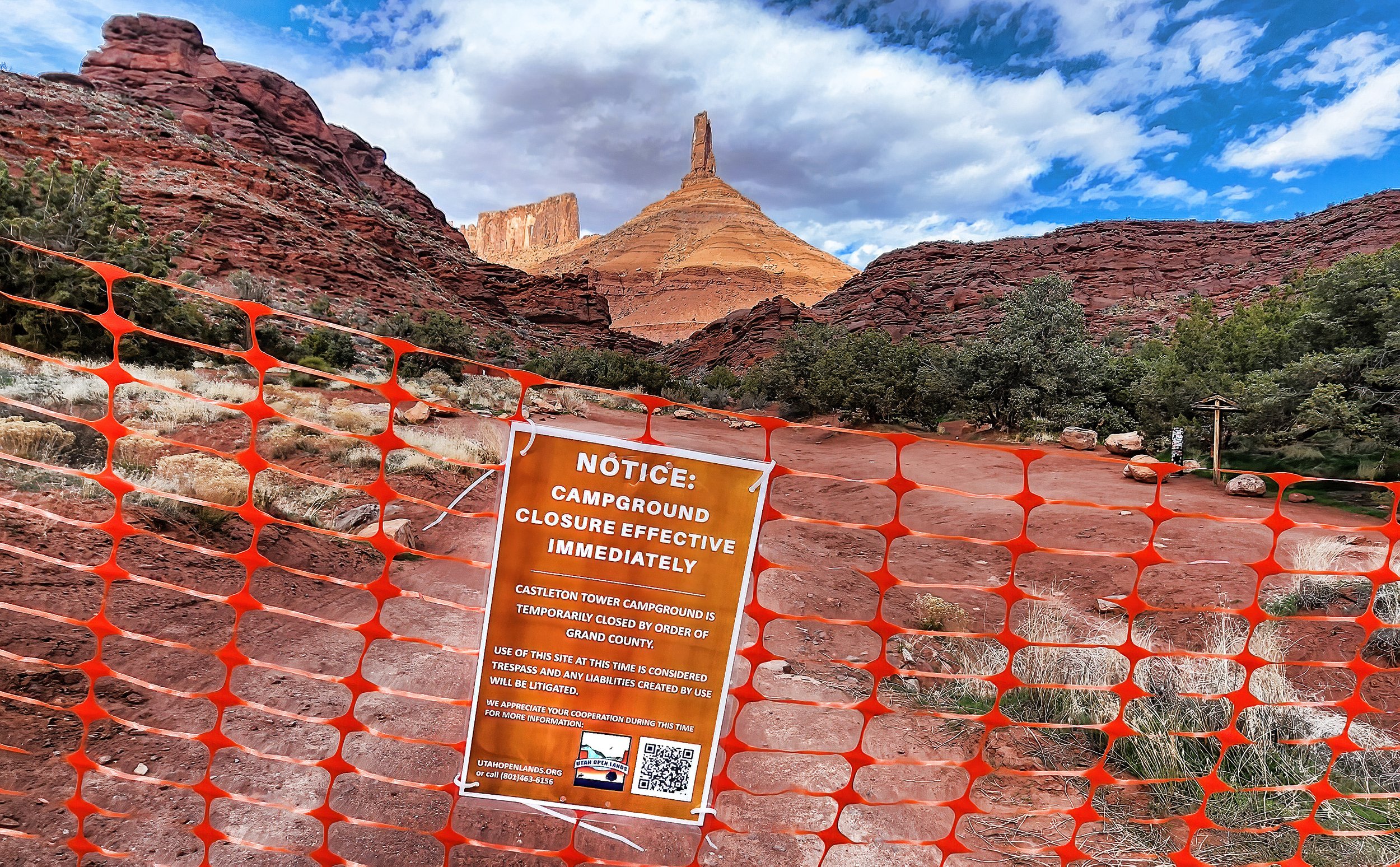
Some details here: Castle Valley Comments and here.
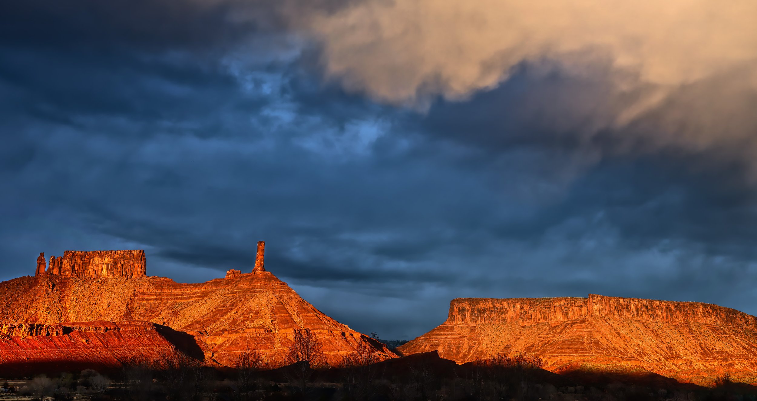
The most dramatic sunsets...
in Castle Valley occur when stormy skies begin to clear around sundown, as clouds rip apart and permit the last low-angle rays of the Sun to flare on the eastern skyline. This evening is such an evening.
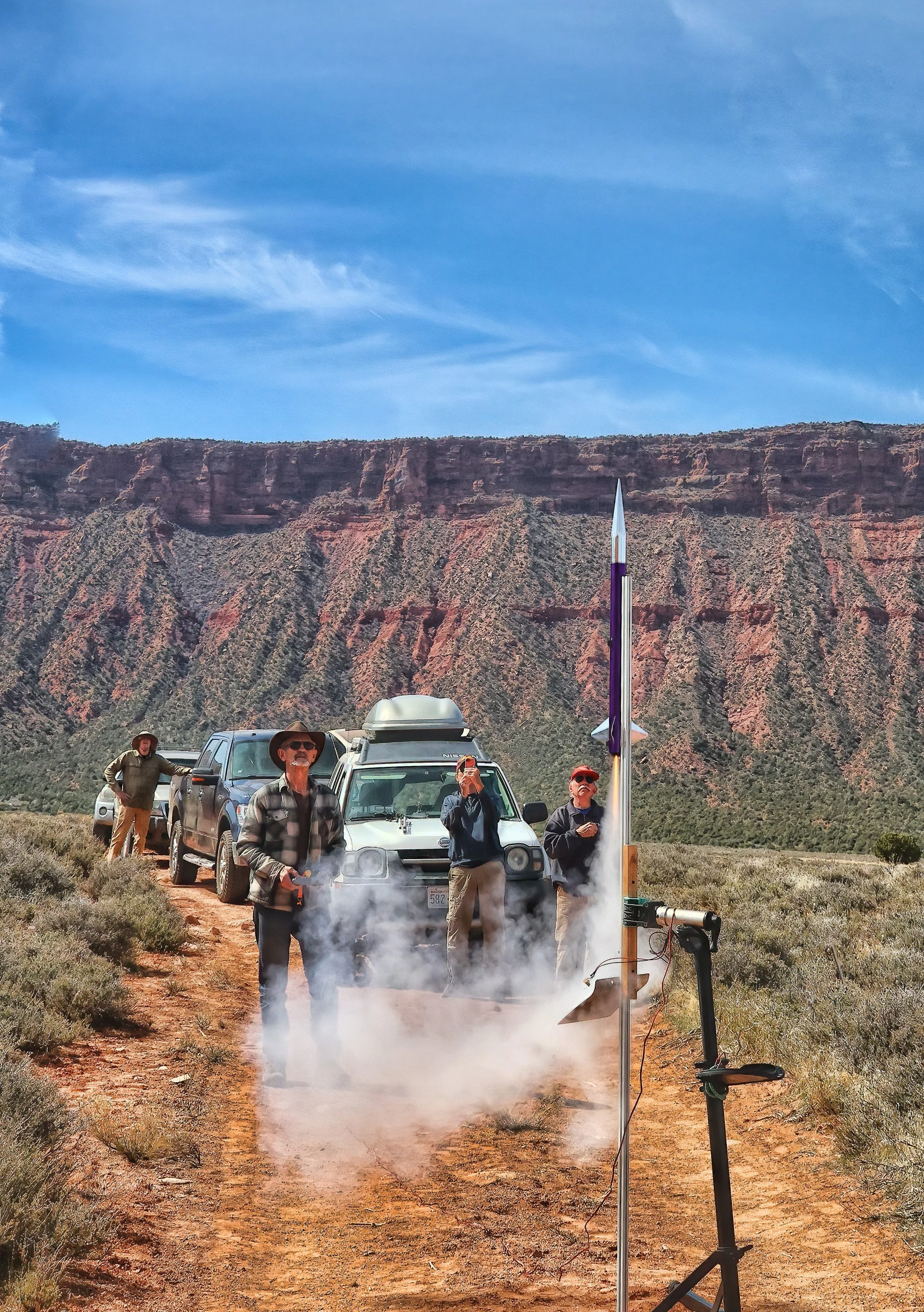
A growing club of rocketeers...
gathered this morning at the Round Mountain Missile Proving Range. It’s not a very diverse group. Heh.
Majestic heading skyward to an undetermined altitude, unknown because the flight recorder was lost, but the rocket was recovered safely under parachute.

Unpainted MOAB is the first rocket to test the more rigid rail system used for higher powered rockets. It flew straight as an arrow to 647 feet on a “F” engine.

GoPro view of MOAB at ignition on the launch rail, about to lift off.

The high flyer of the morning was the Arcas on a “E” engine, with an apogee at 1,482 feet (before the loss of the altimeter). The wind was picking up so the launch rod was tilted in order to accommodate for parachute drift during descent.

Wide view of the Round Mountain Proving Ground.
Denying access to public lands...
the Bureau of Land Management arbitrarily closes the old Castleton grade, even to bicycles. It’s not a biologically sensitive area. There was no informing discussion with the local community. No comments taken. Screw the staff of the BLM.

UPDATE; Three weeks later someone has ripped down the closure signs. Hayduke lives!
Career Day for Moab middle schoolers...
brought them to the Utah State University campus where one of the activities involved model rocketry. We launched and successfully recovered four rockets in a series of demonstrations as small groups of students rotated through the various activities. It was big and chaotic fun.


Observing the first day of spring...
by lofting a rocket.

Blast off from the driveway with Parriott Mesa in the background.

The Patriot clearing the launch rod and flying to a 486 foot apogee.

Annotated profile of a perfect flight and parachute deployment. The rocket landed softly about 150 feet away from the pad.
Paraglider hanging with the Moon...
above Castleton Tower this afternoon on an absolutely gorgeous day. It’s the vernal equinox, too, so tomorrow is the first day of spring.
Click on image to enlarginate.
It may look menacing...
but it’s just a model rocket, albeit a very big model rocket. The HV Arcas by Aerotech stands 56 inches (142 cm) tall and is mounted on a rigid rail used for launching high powered rockets. I will seek Level 1 certification this coming summer from the National Association of Rocketry in order to fly this impressive projectile on larger engines to several thousand feet in altitude. It’s important to have goals in retirement. Go big or stay home.


Note: The 1010 aluminum launch rail stands 7.5 feet tall (2.3 meters).
A peeping muley...
at the kitchen window last evening with its nose nearly pressed up against the glass. There’s still a small herd hanging out in the valley and several still frequent my bird feeders and bird bath around dusk.

Mule deer (Odocoileus hemionus).
Slow and lingering late winter storms...
maintain the snowpack in the high country at near normal levels while misting the lower valley with light rains. Springtime approaches in the high desert.

A window to the snowy high country opens behind Round Mountain this afternoon.
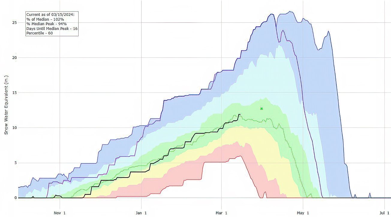
Lasal Mountain (572) SNOTEL hydrograph: Black line indicates the current water year snow water content, closely following the median value (green line) based on 41 years of record at this station. Last year’s historic snowpack is represented by the purple line for comparison. (Graph from NCRS SNOTEL network.)
17 March 2024 update: This SNOTEL station now reports 119% of median SWE!