on the shore of Skjálfandi bay and has become a center of whale watching in northern Iceland due to whales of different species that frequently enter the bay.
Click on image to enlarge.
on the shore of Skjálfandi bay and has become a center of whale watching in northern Iceland due to whales of different species that frequently enter the bay.
Click on image to enlarge.
is extraordinarily impressive and is about 100 meters (330 feet) wide and has a drop of 44 meters (144 feet). Located in Jökulsá á Fjöllum, a large canyon cut by several volcanically-generated outburst floods — jökulhlaups — during the middle Holocene.
Dettifoss on a snowy spring day. (Click image to enlarge.)
contributes approximately 30 percent of Iceland’s electricity, the other 70 percent coming from hydropower. This is the Krafla facility, rated at 60 megawatts.


One wonderful benefit of a nearby power plant are the hot pools for soaking. Our group spent two hours relaxing here in the therapeutic waters.
at Námafjall Hverir were exceptionally dramatic this morning, given the cold temperatures and recent snowfall.
Click on image to enlarge.

at Skutustadir, on the south shore of Lake Myvatn in northern Iceland, are the result of steam explosions beneath a lava flow. Geologists use the term “rootless cones” to describe these unique volcanic landforms.


in northern Iceland drops from a height of 12 meters (39 feet) across a width of 30 meters (98 feet).


across the Vatnajökull ice cap was largely obscured by clouds today, but here are a couple of shots from the air.

Our charter aircraft, a Dornier 328 turboprop.

Braided outwash channels near Höfn, Iceland.

Glacially carved valleys south of Akureyri, Iceland.
was loads of fun this afternoon!
The adventurous members of Apex Expedition’s snowmobile team. (Click on image to enlarge.)
out for a paddle this morning.


Common Eider (Somateria mollissima): Three adult males, two adult females and one juvenile male.
belonging to the greater Breiðamerkursandur glacial plain, located near the Jökulsárlón glacier lagoon. Large chunks of glacial ice that have calved from the glacier front are worked and polished by the heavy surf into lovely shapes and colors.


was the location of a glacier hike today, where we strapped on crampons and climbed high into the ice. Nice!


Apex Expeditions co-leader Kevin Clement.
gushed from the subglacial lake Grímsvötn in Vatnajökull, Iceland. In November 1996 a surge of floodwater from beneath the Skeidarárjökull glacier inundated the Skeidarársandur outwash plain seen here, destroying a large segment of the Ring Road on the southern coast.

is the biggest lava flow in the world, created by the eruption of Laki volcano in 1783-84. The enormous basaltic lava flow covers 565 square kilometers (218 square miles) yet it averages only 12 meters (40 feet) in thickness. It is covered with a soft and vibrant arctic hair moss as shown in the image below.

at Kötlujökull Mýrdalsjökull, the fourth largest glacier in Iceland.

The dark material incorporated into and on the glacial ice is ash and cinder from countless volcanic eruptions.

The interior of a natural tunnel in the glacial ice.
drops 60 meters (197 feet) and one can explore behind the enormous curtain of water.


Skógafoss, a short distance from Seljalandsfoss, is one of the biggest waterfalls in Iceland, with a width of 25 meters (82 feet) and a drop of 60 meters (200 feet).
last erupted in April 2010 and disrupted air traffic over northern Europe for more than a week.

The volcanic edifice illuminated by the morning light.

NASA image of eruption plume emanating from the southern tip of the island.
rises to 1,450 meters (4,756 feet) and today we drove to the summit of the second largest ice cap in Iceland in two “super jeeps.”

View of the ice cap from the lower outwash plain.


View southeastward from the summit of Langjokull glacier across the rift valley (mid-ocean ridge) toward Hekla volcano, approximately 50 km (30 miles) distant.
were the highlights of our first full day of exploration east of Reykjavik, Iceland. An outstanding day!

Steam column from Strokkur geyser following an eruption.

Water mound signaling the beginning of an eruption.

Eruption underway!

Strokkur Geyser in full eruption, with column height approaching 35 meters (115 feet).

Gullfoss waterfall on the Hvíta River, plunging 32 meters (105 feet) in two steps.

Lower waterfall at Gullfoss with glacially scoured columnar basalt in the foreground.

Rift valley at Þingvellir National Park, a sub-aerial portion of the northern Mid-Atlantic Ridge divergent margin. In this view towards the southwest, rocks to the right side of the path belong to the North American plate while those on the left are part of the Eurasian plate.
of the island nation of Iceland where more than half the country’s population is concentrated in this urban center.
Panorama of Reykjavik (click image to enlarge).

The 240 ft (73 m) high tower of Hallgrimskirkja cathedral, the architecture of which is inspired by columnar jointed basalt.
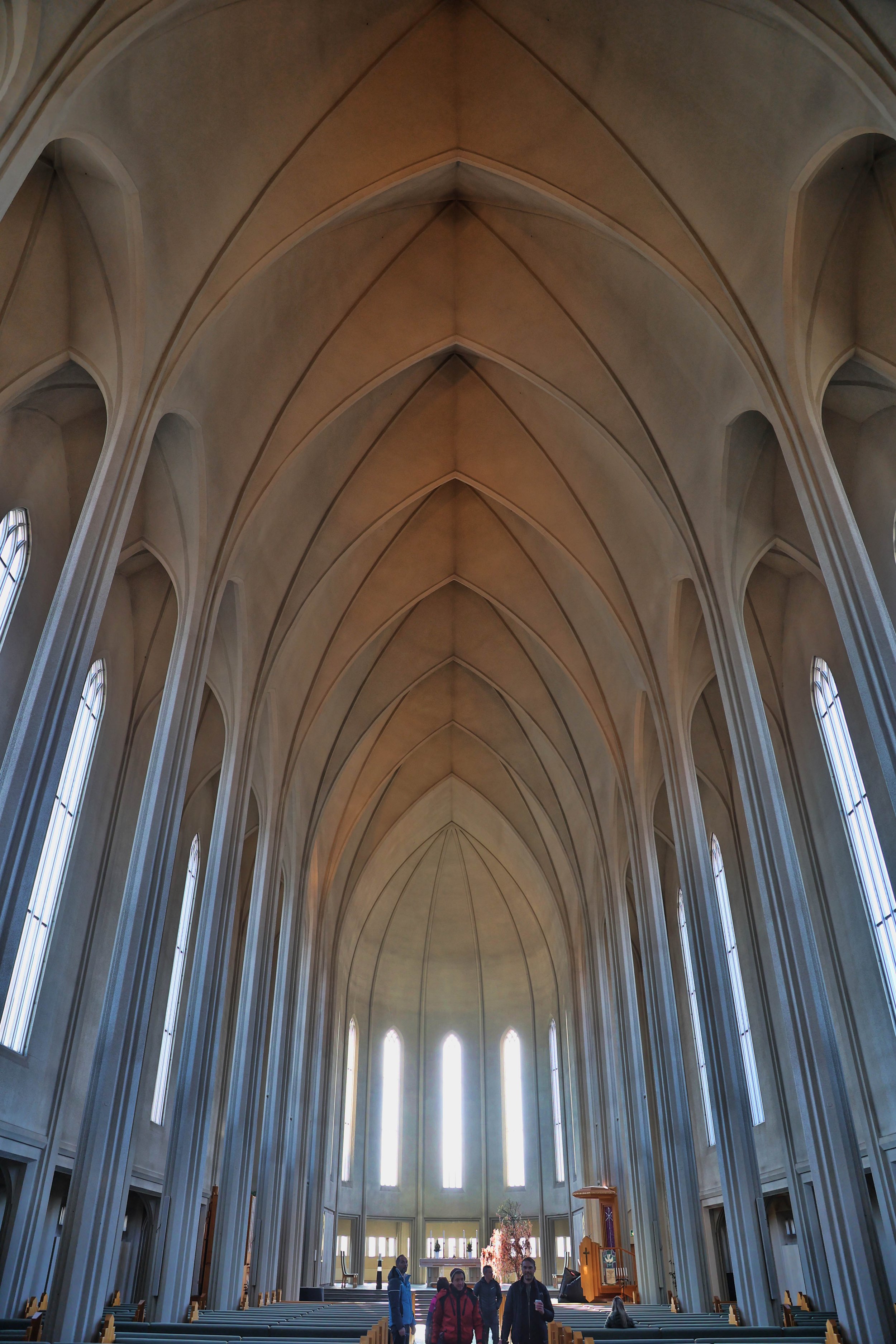
The spartan interior of Hallgrimskirkja cathedral.
between Seattle, Washington and Keflavík, Iceland that I’ll be flying today, visualized in the graphics below. Remember, geologists always get window seats!

The straight-line air route appears to follow an arc of a circle when visualized on a Mercator projection of the globe.
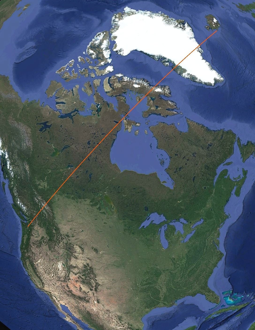
The air route from SEA to KEF is 3,622 miles (5,830 km) and takes about 7.5 hours flight time.